At Terra Visus, we believe that the combination of the right technology, the right partners, and the right processes is what drives real impact. That’s why we’re always excited to share stories that highlight how collaboration brings results to life in the field.
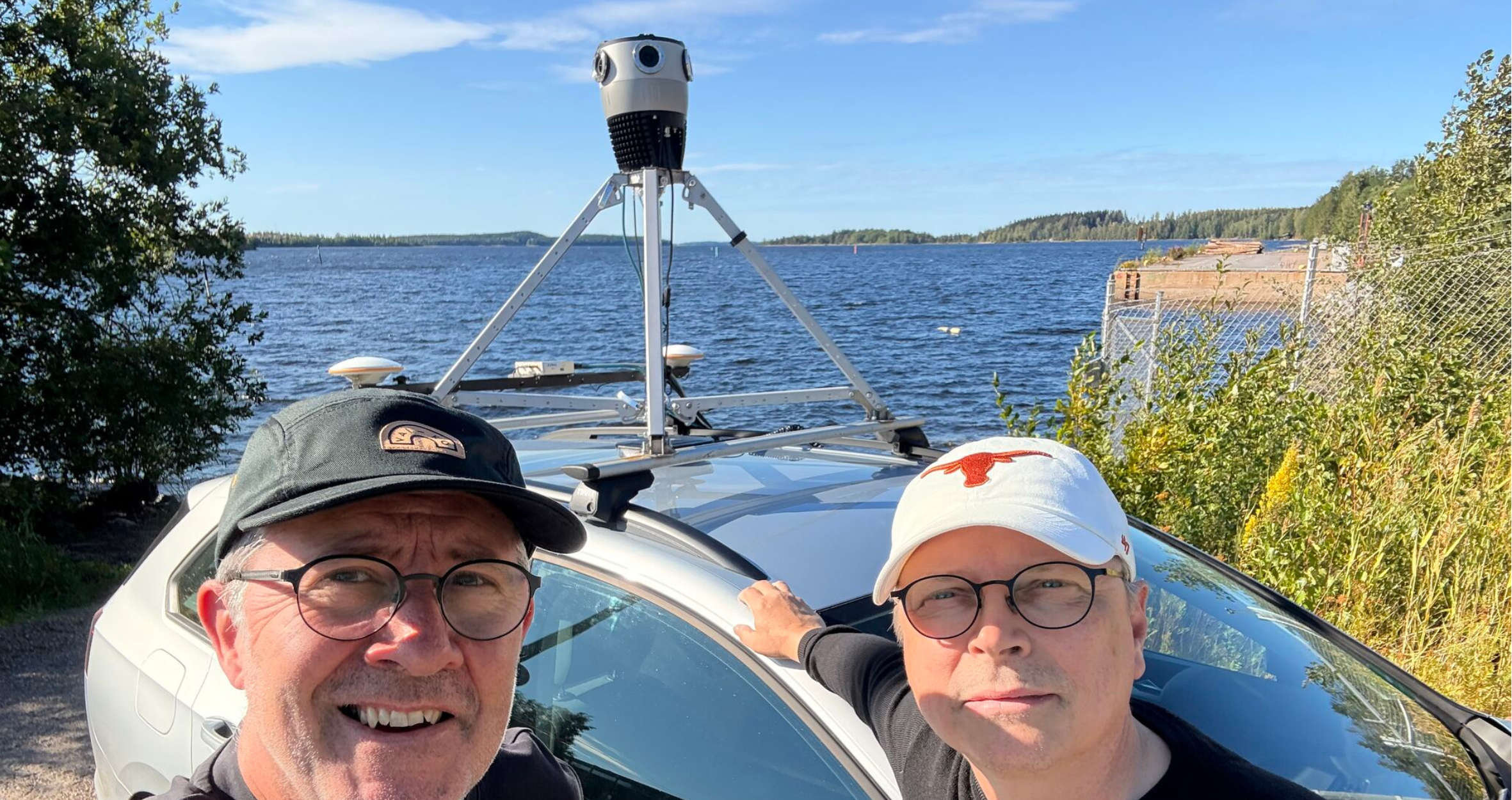
One of our recent projects in Finland is a great example of this philosophy in action. Working alongside our trusted partners, Autori and Mosaic, we set out to capture hundreds of UKM's of high-resolution, street-level imagery to support road and street maintenance, as well as the management of critical infrastructure assets.
The Challenge of Road Data
Municipalities and road authorities face an ongoing challenge: how to maintain, upgrade, and manage road networks effectively whilst keeping costs down. Traditional methods of data collection such as manual inspections, traditional surveying, or inconsistent reporting can often be slow, expensive, and difficult to scale.
That’s where our very own Capture as a Service (CaaS) comes in. By combining the very best mobile mapping technology with streamlined data delivery and intelligent management platforms, we help our customers access the information they need quickly, reliably, and at scale.
Mapping Hundreds of UKM's Across Finland
For this particular project, our team deployed the Mosaic X 360° mobile mapping camera with RTK and XVN (a dual RTK GNSS/INS system). This combination ensured centimetre-level accuracy, while capturing hundreds of UKM's of roads across Finland.
The Mosaic X camera is designed for rugged, real-world conditions. Whether in urban environments or remote stretches of road, it consistently delivered high-resolution 360° imagery, ensuring every sign, line marking, and roadside feature was captured in detail.
Seamless Oversight Through Autori
But capturing data is only part of the story. Once the imagery was collected, Autori’s SaaS platform came into play. Their system ensured smooth project oversight, progress tracking, and integration into customer workflows. With Autori, the project data wasn’t just accurate, it was usable, accessible, and ready to support decision-making from day one.
This powerful blend of Mosaic’s robust hardware, Terra Visus’s operational expertise, and Autori’s intelligent SaaS tools meant the project ran efficiently, with no wasted time or resources.
Why This Matters for Road Authorities
The end result was more than just a dataset. By receiving high-resolution, street-level imagery of their roads and assets, the customer can now:
- Visually plan and manage infrastructure upgrades and maintenance.
- Assess conditions remotely, without dispatching teams for every inspection.
- Save time and reduce costs through better-informed decisions.
- Future-proof asset management by integrating imagery into long-term planning.
In short, the project delivered data of the highest quality, on time, and with ease
The Power of Three
This project is only the beginning. It marks the first of many CaaS initiatives where Terra Visus, Autori, and Mosaic are working together to deliver actionable insights from the road. It’s proof of the old saying: good things come in threes.
When you combine field-proven hardware, intelligent software, and experienced operators, you create a workflow that’s scalable, repeatable, and capable of supporting road authorities everywhere.
Looking Ahead
At Terra Visus, we see this as a model for the future of infrastructure data capture. By continuing to build strong partnerships and deliver bespoke CaaS solutions, we’re helping governments, municipalities, and private organisations see their world more clearly and manage it more effectively.
A big thank you to our partners, Autori and Mosaic, for making this project a success. Together, we’re proving what’s possible when innovation and collaboration meet on the road.
Learn More
If you’re interested in learning more about our bespoke Capture as a Service offering or exploring the data we have available for license, we’d love to hear from you.
Contact Terra Visus today for more information on CaaS and the data we have available for immedite license.
About Terra Visus
Terra Visus is a leading provider of street-level imagery and LiDAR data, supplying some of the world's largest technology companies and organisations, providing an on-demand, global street-level data marketplace for data collectors and buyers.
Founded in 2021, Terra Visus is headquartered in Edinburgh, Scotland.
Follow us on LinkedIn to keep up to date on what we're up to!
For further information:
sales@terravisus.com
www.terravisus.com
Check out our partners:
🌐Autori
🌐Mosaic